Posts

Showing posts from March, 2017

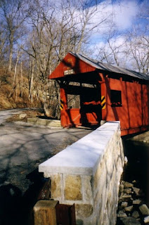
Geiger Covered Bridge

Image
(Doug Kerr - January 2013) Known for it's uniquely shaped stepped portals, Geiger's Covered Bridge is the fourth covered bridge to cross Lehigh County's Jordan Creek.  The 112 foot long Burr Truss bridge was built in 1860.  The bridge sits slightly over a mile downstream from the Schlicher Covered Bridge.  If you prefer to be a little more adventurous, park your car on the east side of the bridge and follow the covered bridge trail.  This 2.7 mile hiking trail loop along Jordan Creek takes you to the Schlicher Bridge and back. (Doug Kerr - January 2013) Bridge Specs: Number: 38-39-05 Design: Burr Truss Built: 1860 Length: 112' Crosses: Jordan Creek Lehigh Valley Covered Bridge Tour - Navigation: Back to Rex's Covered Bridge Ahead to Schlicher's Covered Bridge Return to Lehigh Valley Covered Bridge Tour Index

Bogert Covered Bridge

Image
(Doug Kerr - January 2013) The Bogert Covered Bridge is the oldest covered bridge in Lehigh County.  Built in 1841, this bridge has a colorful and unique history.  The bridge is named after Peter Bogert who purchased the land surrounding the bridge in 1744.  Bogert was a German immigrant who also was the first inhabitant of what is now known as "Hunter's Cabin" which stands nearby.  The cabin was built around the same time that Bogert purchased the land. Hunter's Cabin sits on the North shore of the Little Lehigh Creek (Doug Kerr - January 2013) The Bogert Covered Bridge has been closed to vehicular traffic since the late 1950s. A pair of accidents in 1956 and 1957 severely damaged the bridge, and it was scheduled for demolition.  Local residents formed the Save the Bogert's Bridge Committee and rallied to save the bridge.  The group was successful, and in 1964, the state turned over the bridge to the City of Allentown.  Today, the bridge is for pedestr

Scott Covered Bridge - Revisited

Image
Earlier this week, I published a blog entry on the Scott Covered Bridge in Greene County.  Thanks to Brian Powell, I learned that the bridge was rebuilt from the floor up in 2007.  The photo below from Brian shows that there wasn't much of the bridge standing in October 2007. Brian Powell - October 2007 Brian would revisit the bridge in June 2009 and took photos of the completed project. Brian Powell - June 2009 Brian Powell - June 2009 Many thanks to Brian for the updated information and allowing us to use his photos of the rebuilt Scott Bridge.  If you want to check out his entire photo set covering the bridge, you can do so here !

Rex Covered Bridge

Image
Bill Symons - Summer 2004 At a length of 150 feet, the Rex Covered Bridge is the longest in the Lehigh Valley.  The Burr Truss bridge was built in 1858.  It is the third of five covered bridges to cross Jordan Creek.  The bridge was added to the National Register of Historic Places in 1980. Bill Symons - Summer 2004 Bridge Specs: Number: 38-39-04 Design: Burr Truss Built: 1858  Length: 150' Crosses: Jordan Creek Lehigh Valley Covered Bridge Tour - Navigation: Back to Wehr's Covered Bridge Ahead to Geiger's Covered Bridge Return to Lehigh Valley Covered Bridge Tour Index 

Wehr's Bridge

Image
Bill Symons - 2004 Wehr's Bridge is the one of five covered bridges that cross Jordan Creek in Lehigh County.  The 128 foot long Burr Truss Bridge was built in 1841.  Originally known as Sieger's Bridge, the term "Wehr's Bridge" became more common after the opening of Wehr's Mill, which was built nearby in 1862.   This bridge along with the nearby Guth Bridge forms South Whitehall Township's Covered Bridge Park that is anchored by both bridges and runs along side Jordan Creek.  The area around Wehr's Bridge is popular for picnics, photography, and fishing. Bridge Specs: Number: 38-39-02 Design: Burr Truss Length: 128' Width: 17' Crosses: Jordan Creek   Bill Symons - 2004  Lehigh Valley Covered Bridge Tour - Navigation: Back to Manasses Guth Covered Bridge Ahead to Rex's Covered Bridge Return to Lehigh Valley Covered Bridge Index

Manasses Guth Bridge

Image
The bridge that anchors the eastern end of South Whitehall Township's Covered Bridge Park is the Manasses Guth Bridge.  It joins the Wehr Covered Bridge as bookends to this unique park along Jordan Creek.  The 129 foot long single span Burr Truss Bridge was built in 1858.  The bridge, which is named after Manasses Guth who lived nearby, was rehabilitated in 2015 and reopened the following year. Manasses (or I've also seen Manassas) Guth Bridge (Bill Symons, 2004) Bridge Specs: Number: 38-39-03 Built: 1858  Design: Burr Truss Length: 129' Crosses: Jordan Creek Lehigh Valley Covered Bridge Tour - Navigation: Back to Bogert's Covered Bridge Ahead to Wehr's Covered Bridge Return to Lehigh County Covered Bridge Tour Index

Scott Covered Bridge

Image
A few miles west of the Greene County town of Rogersville sits the Scott Covered Bridge. The county owned 41 foot queen truss bridge is within sight of traffic along rural PA Route 21.  All photos on this page were taken by the author in July 2004.  In 2007, the bridge would see a total rebuild.  To see photos of the bridge after the reconstruction, we've added a new entry, Scott Covered Bridge - Revisited . Bridge Specs: Number: 38-30-28 Design: Single Queen Truss Length: 41' Crosses: South Fork 10 Mile Creek Built: 1885   Directions: From Waynesburg:  Follow PA 21 through Rogersville.  Continue on PA 21 West through Rogersville approximately three miles.  Turn left onto Covered Bridge Road.  The bridge will be immediately come into view.

Colvin Bridge

Image
Colvin Covered Bridge (Bee Family) The Colvin Bridge is one of the oldest of Bedford County's numerous covered bridges.  Originally built by J.H. Thompson in 1880, the bridge was refurbished in 1997 by Kee-ta Quay Construction.  The Colvin Bridge along with the Palo Alto Bridge is one of two multiple king post bridges in the county.  A third, the McDaniels, was destroyed by fire on Easter Sunday in 1988.  The county owned bridge is also known as the Calvin or Shiller Bridge. Colvin Covered Bridge (Bee Family) Bridge Specs: Number: 38-05-24 Design: Multiple King Post Length: 72 feet Crosses: Shawnee Creek Built: 1880   Directions: From Bedford: Follow US 30 West to Schellsburg, one block after the PA 96 intersection (traffic light)  turn left onto Pitt Road, then continue Southwest on Mill Road (Township Road 443) to bridge.

Centerville

Image
CENTERVILLE - Founded 1821.  In the early days of the National Road, Centerville was a key stopping point between Uniontown and Washingon, hence the name.  Within the town and just outside of its limits are several historic inns and taverns that date to the National Road.

Sawhill Covered Bridge

Image
Sawhill Bridge prior to Ivan damage and reconstruction - December 2003 Along PA 221 in rural Western Washington County sits the Sawhill Bridge.  This 100 year old structure sits quietly in one of Western PA's most remote areas.  The Sawhill Bridge was heavily damaged from the remnants of 2004's Hurricane Ivan causing it to lean and making it impassable.  A nearly $500,000 reconstruction project occurred in 2005 that rebuilt the entire bridge from its foundation.  (1) A look at Buffalo Creek - December 2003 In July 2009, I was able to revisit the bridge again after the rehabilitation project.  The bridge was in great shape and should be in usable condition for years! July 2009 Bridge Specs: Number: 38-63-34 Design: Single Queen Truss Length: 57' Crosses: Buffalo Creek Built: 1915 Sawhill Bridge - July 2009 Directions: From I-70 take Exit 11.  Follow PA 221 through Taylorstown.  Bridge is approximately three miles north of Taylorstown on

Henry Bridge

Image
O ne of two covered bridges that sit within the grounds of Mingo Creek County Park , the Henry Bridge is one of my favorite settings for a covered bridge.  The Henry sits about one mile downstream from the Ebenezer Church Bridge.  The two bridges are featured in an eight bridge, Covered Bridge Festival , that runs in Washington and Greene Counties every September.  The bridge may be closed at various times due to its age and condition as it is well over 130 years old. Bridge Specs (1) : Number: 38-63-16 Design: Single Queen Truss (on I-beams) Length: 41' Crosses: Mingo Creek Built: 1881   Directions: From Washington follow PA 136 for about 12 miles to the Entrance of the Park, the bridges are located inside the park. 

Ebenezer Church Bridge

Image
O ne of the two covered bridges that are featured inside the grounds of Mingo Creek County Park , the Ebenezer Church Bridge did not always cross Mingo Creek.  The bridge used to cross Maple Creek in Ginger Hill but was moved to the County Park in 1977.  The Ebenezer and the Henry Bridge - the other bridge that is located within the park - are one of eight covered bridges in Washington and Greene Counties as part of the Covered Bridge Festival that is held every September. The bridge was originally located at nearby Ginger Hill where it crossed the South Fork of Maple Creek.  The bridge was dismantled in 1975 before moving to its current home in 1977. Bridge Specs : Number: 38-63-14 Design: Singe Queen Truss (heavily modified on I-Beams) Length: 38' Crosses: Mingo Creek   Directions: From Washington follow PA 136 for about 12 miles to the Entrance of the Park, the bridges are located inside the park.  

Wright or Cerl Bridge

Image
T he Wright or Cerl Bridge is one of the 23 covered bridges that can be found in Washington County.  This bridge can easily be viewed from Interstate 70 near Kammerer.  The 24' single span King Truss bridge carries Sumney or Ridge Road over the North Branch of Pigeon Creek.  Although the date of original construction is unknown (estimated time period 1875-1899), the bridge was placed on the National Register of Historic Places in 1979 and was restored in 1998-99.  Bridge Specs : Number: 38-63-30 Design: Single King Truss Length: 24' Crosses: North Branch Pigeon Creek Directions: Exit 31 I-70, turn South.  Take immediate right onto School Road.  Follow School Road for approximately 0.7 miles.  Turn right onto Short Cut Road.  Continue straight onto Ridge Road to Bridge.  Please note that Ridge Road no longer crosses Interstate 70.   

Dallastown

Image
DALLASTOWN - Founded 1736, incorporated 1866. Dallastown is named for Vice President George M. Dallas , who served under President James K. Polk.

North East

Image
NORTH EAST - Founded 1794. The northeasternmost town in the northwesternmost county of Pennsylvania, Erie County. North East is in the heart of the grape country in a large part because of its proximity to Lake Erie, which makes the climate favorable to growing fruit.