Posts

Showing posts from 2018

York Springs

Image
YORK SPRINGS - Founded 1808.  Named after local mineral springs that attracted visitors from Philadelphia and Baltimore as a summer resort during the early 1800s.  The town was originally named York Sulphur Springs , but it was eventually shortened to what it is called today. Photo taken by Doug Kerr.

Yardley

Image
YARDLEY - Founded 1682.  Settled by the Yardley, also spelled Yeardley, Family and site of Yardley's Ferry and Mill.  Ferry service connected Yardley, PA to Ewing, NJ until May 1, 1876.  The town was also known as Yardleyville into the 1800s. Photo taken by Doug Kerr.

Wysox

Image
WYSOX - Founded 1773. From the Indian Wisachgimi meaning "Place of Grapes." Wysox is where French exiles loyal to Louis XVI built a safe haven for themselves and Marie Antoinette.  Antoinette never made it as she was captured and executed before making it to Pennsylvania.  Known as the French Azilum , the area was an intended home for French refugees during the French Revolution. The village is also known for a utility pole shaped as a giant pencil . Photo taken by Doug Kerr.

Towanda

Image
TOWANDA -Founded 1784.  The named of the Bradford County Seat comes from the Algonquian Indian word meaning, "Here our great dead are resting."  The town is home to about 2,900 residents. Photo taken by Doug Kerr.

Shortsville

Image
SHORTSVILLE - Founded 1840.  Named for the Short Family who were early pioneers in the area. Photo taken by Doug Kerr.

Shohola and Shohola Falls

Image
SHOHOLA - Founded 1772.  Named for Shohola Creek Indian Tribe.  Shohola is from the Lenni Lenape Native American language meaning " Place of Peace ".  Shohola is located along the Delaware River.  The nearby Shohola Falls along Shohola Creek is a popular hiking and photography destination. Shohla Falls is located about nine miles south of Shohola just off of US 6.  The falls which are located along Shohola Creek just north of Shohola Marsh Reservoir are easily accessible via a 0.8 mile loop trail.  The main cascade of Shohola Falls is about 70-75 feet wide and about 50 feet tall. It is best advised to exercise caution along the ledges  as they can be extremely dangerous especially in winter due to icing. Photos taken by Doug Kerr. Further Reading:   Shohola Falls @ UncoveringPA.com Getting There:

Rome

Image
ROME - Founded 1795.  Bradford County town named for Rome, Italy - "The Eternal City." Photo taken by Doug Kerr.

Pleasantville or Alum Bank

Image
PLEASANTVILLE - Incorporated 1871.  It appears that this small village of around 200 people hasn't completely decided on a name.  Located in Bedford County, this community is one of three Pleasantville's in the state.  However, it is also known as Alum Bank.  Prior to that, the community was formerly called Dubbstown.  Photo taken by Doug Kerr.

New Oxford

Image
NEW OXFORD - Founded 1782.  The name of the town comes from three parts, near a creek ford there was an old inn with an ox head on its sign.  The term 'New' came about in order to distinguish itself from Oxford in Chester County.  Today, it's known as the antique capital of Central Pennsylvania . Photo taken by Doug Kerr.

Miniature Railroad & Village at Pittsburgh's Carnegie Science Center

Image
The Miniature Railroad & Village at the Carnegie Science Center has been a Pittsburgh tradition for over 60 years.  Whether at the old Buhl Planetarium or now at the Science Center, generations of Western Pennsylvania families have visited this exhibit.  Growing up in Western Pennsylvania, this was an annual Winter and Christmas time attraction.  In fact, the exhibit traditionally was only on display for four months from November through February. When I began writing about our visit to the Miniature Railroad, I kept struggling over how to discuss the exhibit's history while including the enjoyment of my two young sons during their first visit.  You see, neither of my boys wanted to leave the display.  Colton, my oldest, insisted on going around the display multiple times to see everything.  While Nash, my youngest, would stay at a certain area minutes at a time in amazement and waiting for the next train to come by. I think that the experience my family and I had ove

World's First Weather Satellite

Image
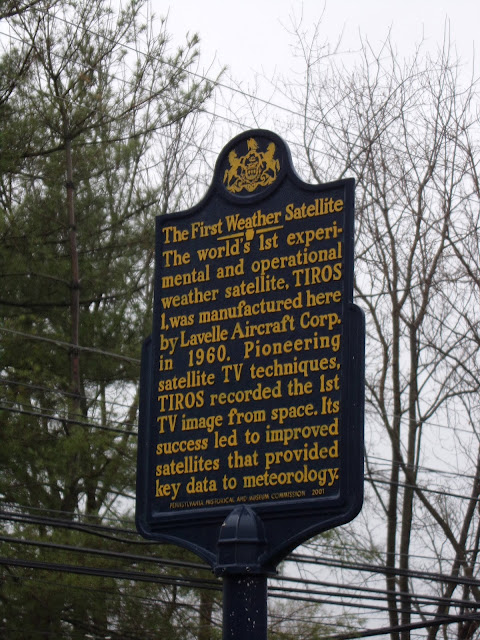
Pennsylvania is home to a number of firsts, including the site where the first weather satellite in the world was constructed. The first edition of the useful application of modern meteorology, known as TIROS I, was a joint collaboration between the Radio Corporation of America (RCA) and Lavelle Aircraft Corporation. RCA was keen on the television and imaging technology of the day, but when it came to the aerospace engineering components and construction of the satellite, they turned to Lavelle, who designed and fabricated the satellite at their office in Newtown, Pennsylvania. While it was the first weather satelling, TIROS I had issues from the get go. TIROS I was launched on April 1, 1960, but due to electrical issues, it was rendered inoperable after only 77 days. Still, it provided many useful weather related images during its short time in operation. Sources and Links: ExplorePAHistory.com - The First Weather Satellite Historical Marker NOAA Satellite and Information S

High Knob Overlook

Image
Nestled on the edge of the woods of the Loyalsock State Forest in Sullivan County is the High Knob Overlook. At around 2000 feet high, the scenic overlook allows for expansive views of the hills and valleys to its west, with breathtaking views of 20 miles out on most days. While it's off the beaten path, the overlook is quite easy to get to, as there are paved roads leading right up to the parking lot for the overlook. The overlook sits on an Appalachian plateau where the hills and valleys were carved by ice during the Wisconsinan glaciation of the last Ice Age. You can easily see the Loyalsock Creek valley, neighboring Tioga and Lycoming Counties, more mountains in the Loyalsock State Forest and more. Spectacular sunsets make the overlook quite popular, and due to the dark skies at night, it's also possible to see people out with telescopes gazing at the night sky. Other popular times to visit the High Knob Overlook are during the month of June when the mountain laurel blo

Forksville

Image
FORKSVILLE - Founded 1810. Named from location at forks of Big and Little Loyalsock Creeks. Forksville is also home to the Forksville Covered Bridge , and next to the covered bridge is the Forksville General Store , which makes an excellent cheesesteak. Nearby to Forksville is the Loyalsock State Forest , High Knob Overlook and Worlds End State Park .

Bookstore now open

Help support our site by visiting the Quintessential Pennsylvania Bookstore .  Here Doug and I will be listing books and other materials that we take along while discovering Pennsylvania.  It can be accessed here !

Wayne

Image
WAYNE - Founded 1880. Formerly "Louella" - Renamed for General Anthony Wayne. This community located on the Main Line west of Philadelphia is near where Anthony Wayne was born in 1745. Sources and Links: USHistory.org - General Anthony Wayne Main Line Homes - History of the Philadelphia Main Line

Ardmore

Image
ARDMORE - Founded 1873. Formerly "Athensville", renamed Ardmore in 1873. The name Ardmore comes from an Irish town of the same name. Located on US 30 about 10 miles west of Philadelphia, Ardmore is one of the famous and affluent Main Line communities that were originally served by the Pennsylvania Railroad's Main Line, which ran from Philadelphia to Bryn Mawr (later to Paoli). Downtown Ardmore is a shoppers' mecca, when one of the earliest official shopping centers in the United States, Suburban Square, opened in 1928. Because of Ardmore's status as a shopping destination, it has been given the nickname of the "Main Street of the Main Line". Sources and Links: Visit Philadelphia - Ardmore Destination Ardmore - Welcome to Destination Ardmore Main Line Homes - History of the Philadelphia Main Line Ardmore Waterford - Explore Ireland's Ancient East - Ardmore, County Waterford

Tri-State Rock

Image
Tri-State Rock (Monument) notes the point where Pennsylvania, New York, and New Jersey meet - even if it is 475 or so feet away. It's not often you can locate the spot where three states meet.  And if you want to go to the exact spot where Pennsylvania, New York, and New Jersey meet well you'd have to take a boat or canoe out to the middle of the Delaware River to find it.  However, for the non-adventurous, you can come pretty close to it, and there's a monument to go with it. The Neversink River (on left) flowing into the Delaware.  It is out here where the three states actually meet. Tri-State Rock is located in Port Jervis, New York and is the "unofficial" point where the three states meet.  The location of the Tri-Point is where two rivers, the Neversink and Delaware, meet.  Tri-State Rock is known historically as Carpenter's Point and a monument noting the tri-point has been in place here since 1882. There are actually two monuments located

McConnell's Mill State Park

Image
Located about 40 miles north of Pittsburgh, McConnell's Mill is one of the most popular state parks within Pennsylvania.  The park borders both sides of Slippery Rock Creek Gorge which was formed as a result of retreating glaciers during the Ice Age.  McConnell's Mill State Park is home to numerous outdoor activities.   Hiking, fishing, rock climbing, canoeing and whitewater rafting are very popular year round activities at the park.   Depending on the depth of the water, Slippery Rock Creek can be classified as a Class II or III rapid.   Most whitewater enthusiasts utilize an approximately six mile route from Rose Point to the Eckert Bridge.   Spring and fall are the most popular times for whitewater at the park. The centerpiece of the park is the former McConnell's Mill and dam.   The first mill at this site was a grist mill built by Daniel Kennedy in 1852.   This mill burned down in 1868 but was quickly rebuilt.   In 1875, Thomas McConnell took over ownersh

Old Mill Village Museum

Image
Old Mill Village Museum is an open air museum located just south of the Susquehanna County town of New Milford on PA Route 848 as a way to preserve the heritage of days gone by in the Endless Mountains region of Pennsylvania. The Old Mill Village Museum was founded in response to the Borough of New Milford's centennial celebration in 1959, as local residents wanted to honor and share the area's history. Land was donated along Meylert Creek on the historic Great Bend-Cohocton Turnpike (in part, today's PA 848), which once brought settlers and commerce to this part of northeastern Pennsylvania. Historic buildings were also donated and moved onto the land, with period artifacts collected for display on site. Local artisans were recruited to demonstrate the arts and skills of the days of yore. As a result, for over 50 years now, the Old Mill Village Museum has been open for people of all ages to learn about what life was like during the early days of New Milford in the 19