Posts

Showing posts from November, 2021

McAlisterville

Image
  MCALISTERVILLE - Founded 1810. Named for Hugh McAlister. McAlisterville was also home to the McAlisterville Academy, which first opened in 1855 and was run by George McFarland, who later served with the 151st Pennsylvania Regiment for the Union Army at the Battle of Gettysburg. After the Civil War, the McAlisterville Academy was also home to a soldiers' orphans school.  How to Get There: Sources and Links: RootsWeb - McAlisterville Academy

Baumgardner Mill Covered Bridge

Image
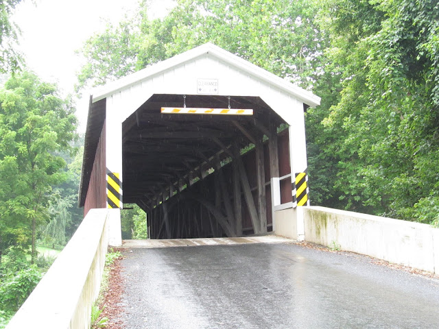
  Also known as Pequea Bridge #10, the Baumgardner Mill Covered Bridge spans over Lancaster County, Pennsylvania's Pequea Creek on Covered Bridge Road near the town of Marticville. Built in 1860, the 105 foot long covered Burr truss arch designed covered bridge was constructed by Davis Kitch at a cost of $1,284. In 1987, the bridge was restored after it was damaged in a flood from the previous year. During the restoration, which cost $200,000, the covered bridge was raised four feet and lengthened by nine feet to protect it from damage in future floods. As with many covered bridges in Lancaster County, the covered bridge is painted red, but has some white trim. As one might expect, the Baumgardner Mill Covered Bridge is located near a historic mill. The history of the mill is one that is longer than the United States itself. There was a mill that was first built at the location in 1775, then a larger mill was built in its place in 1806. Ownership of the mill changed hands countless

Freeburg

Image
  FREEBURG - Founded 1796. Originally called Straubstown for founder, Andrew Straub. How to Get There:

Biglerville

Image
  BIGLERVILLE - Founded 1817. Named for Governor William Bigler. Home of the National Apple Museum , Biglerville was renamed from Middletown in 1903, as there was another borough named Middletown located in Pennsylvania. How to Get There: Sources and Links: The Borough of Biglerville - History

Bendersville

Image
BENDERSVILLE - Founded 1832. Named for Henry Bender, pioneer. Bendersville is located in Adams County, just north of the borough of Biglersville. How to Get There:

Ryot Covered Bridge

Image
The 86 foot long Ryot Covered Bridge gets its name from the nearby town of Ryot, located in Bedford County, Pennsylvania. Spanning over the Dunning Creek, the bridge is designed in the Burr arch-truss style. The original construction of the bridge was approved by grand jury on April 23, 1867, crossing at the Jacob Beckley Fording of the Dunning Creek. The surveyor for the bridge was Samuel Ketterman and the viewers of the bridge's construction were Hirman Davis and William Kirk. With that, the Ryot Covered Bridge first opened to traffic in 1869. A major restoration of the Ryot Covered Bridge took place in 1995. Unfortunately, just seven years later, in 2002, the bridge was burned down by teenaged arsonists. The Bedford County Commissioners quickly committed to the restoration of the bridge and to an accelerated schedule for its reconstruction. P. Joseph Lehman, Inc., Consulting Engineers was chosen to undertake the bridge's rehabilitation and reconstruction. Due to the restorat

Summerville

Image
SUMMERVILLE - Founded 1812. Named for founder Summers Baldwin. Located in Jefferson County, the original name for Summerville was Troy, which is also the name of a community in northern Pennsylvania. How to Get There: Sources and Links: Summerville Public Library - Summerville Story Project

Buttonwood Covered Bridge

Image
Just a stone's throw away from US 15 and PA 284 in the hills of Buttonwood is the Buttonwood Covered Bridge. Built in 1898 and restored in 1998, this 74 foot long covered multiple Kingpost through truss designed covered bridge is just one of a handful of covered bridges found throughout Lycoming County. Due to its historic nature, the Buttonwood Covered Bridge was added to the National Register of Historic Places on July 24, 1980. Local legend states that this covered bridge had once washed downstream on the Blockhouse Creek during a major flood, and that after the water receded, the bridge was hauled back to its original site by horses. The Buttonwood Covered Bridge is in a rural area, surrounded by farms, serene hillsides and a sawmill. But due to its proximity to US 15, it's an easy detour off of the exit for PA 284 to see the bridge, by heading north from the exit and going onto Covered Bridge Road. Approaching the Buttonwood Covered Bridge. Inside the covered bridge. An ol

Goodville

Image
  GOODVILLE - Founded 1815. Named for Peter Good, early landowner and settler. An insurance company based in Lancaster County, Pennsylvania by the name of the Goodville Mutual Casualty Company, takes its name from Goodville. How to Get There: Sources and Links: Goodville Mutual Casualty Company - Company History

Josiah Hess Covered Bridge

Image
  The 110 foot long Josiah Hess Covered Bridge is located on Huntington Creek in Fishing Creek Township. One of 23 historic covered bridges in Columbia County, the covered Burr arch-truss designed Josiah Hess Covered Bridge was constructed in 1875 by Joseph Redline and W.J. Manning at a cost of $1,349.50. Today, the bridge is only open to pedestrian access, providing a nice place to get photos, have a picnic or to go fly fishing. The covered bridge provided access to the Hess sawmill and farm. The bridge's namesake, Josiah Hess, was part of the 4th generation of Hess family members who called Pennsylvania home. Johann Conrad Hess, just 16 years old, climbed aboard the ship Glasgow in 1730 and set out on his journey to the New World and Philadelphia. It wasn't long after that when the Hess family migrated elsewhere in Pennsylvania, establishing farms and businesses in Columbia County. Now owned by the Columbia County Covered Bridge Association, it has been restored, and rededica

Heidlersburg

Image
  HEIDLERSBURG - Founded 1812. Originally Starrytown, renamed for John Heidler. How to Get There:

Stillwater Covered Bridge

Image
  The Stillwater Covered Bridge is one of 23 covered bridges found within the borders of Columbia County, Pennsylvania, which is the third largest concentration of covered bridges throughout the Commonwealth of Pennsylvania. Many of these covered bridges are located along Fishing Creek, north of Bloomsburg. This includes the Stillwater Covered Bridge, located in the Borough of Stillwater. Built in 1849 by local settler James McHenry, bridge construction of this 168 foot long covered Burr arch-truss designed bridge cost $1,124 to build. This bridge is now closed to motor traffic, but you can leisurely enjoy your time visiting the bridge or have a picnic inside of the bridge. While you can spot the bridge from PA 487, you can access the bridge through a couple of local streets on the east side of PA 487 in Stillwater. Side profile of the Stillwater Covered Bridge. Inside the bridge. Bridge over Fishing Creek. Fishing Creek. Leaving the covered bridge on the narrow Paperdale Road. How to

Churchtown

Image
  CHURCHTOWN - Founded 1740. Named for the prevalence of churches in early days. Churchtown also boasts a lot of history. Located in Caernarvon Township in eastern Lancaster County, the village of Churchtown boasts a lot of history. The first settlers of the oldest Amish settlement still in existence in Pennsylvania, the Lancaster Amish settlement, first settled near Churchtown. Of course, there are also the churches, with the Bangor Episcopal Church, Caernarvon Presbyterian Church and Edward Davies House having been listed on the National Register of Historic Places. How to Get There: Sources and Links: PlaceAndSee.com - Churchtown

Blue Ball

Image
  BLUE BALL - Founded 1766. This community in Lancaster County's East Earl Township was named for the Blue Ball Hotel. While the name of this town in the Pennsylvania Dutch Country may make some people giggle, the origins of the town name of Blue Ball are pretty straight forward. The town is named after an 18th Century inn which was located in the town. The owner hung a blue ball on the building, referring to the inn as "The Sign of the Blue Ball." The name stuck as people recognized the inn for its blue ball, and the rest is history. How To Get There: Sources and Links: Discover Lancaster - The Wacky Town Names of Lancaster County

Cochranville

Image
COCHRANVILLE - Founded 1725. Formerly "Cochran's Inn". Named for James Cochran, early settler. In 1724, James Cochran, after whom the village in West Fallowfield Township has been named for, came to the Octoraro Valley with a small band of Scotch-Irish settlers and opened a roadside inn next to the Shawnee Indian camp. When the post office was established, the name was spelled Cochransville, but the "s" was removed by the United States Post Office Department in 1884. How to Get There: Sources and Links: Cochranville History - Place Names

Montandon

Image
  MONTANDON - Founded 1825. Named for Peter Montandon, famous Huguenot leader. Formerly Cameronia. Montandon was originally a railroad station called Lewisburg Junction and the name of the town was changed to Cameronia in 1861 after William Cameron, who was locally known for canal construction between Lewisburg, Pennsylvania and the east side of the Susquehanna River. The name of the town changed to Montandon in 1867 due to mail being sent to a post office to a different town named Cameron, in Cameron County. How to Get There: Sources and Links: Valley Girl Views - When Montandon Was, Briefly, Cameronia

Red Lion

Image
  RED LION - Founded 1786, incorporated 1880. Named from a nearby tavern sign. The tavern was named Red Lion after a tavern in England, and was a prominent stopping place for travelers taking the public road from Wrightsville and the Susquehanna across York County and the state of Maryland to the city of Baltimore. The Red Lion Tavern was said to be a characteristic old time public inn, with the picture of a lion painted red in front of the house. Tradition says that the lion was not a voracious one that scared away thirsty visitors, but rather a mild, peaceful sort of fellow, with an inviting look.  Red Lion, Pennsylvania was also once famous for the many brands of cigars made in the town. In fact, it was the cigar making capital of the world, producing millions of cigars per month. For the annual New Year celebration, Red Lion Borough raises a giant cigar instead of dropping a ball. Red Lion was once responsible for manufacturing roughly 10 percent of the cigars made in the United St

Banks Covered Bridge

Image
Built in 1889, the Banks Covered Bridge is a Burr Arch truss designed covered bridge in Lawrence County, Pennsylvania, spanning over the Neshannock Creek at a length of 129 feet. There aren't many covered bridges that dot the landscape in this corner of western Pennsylvania, but you'll often see local pedestrians, motor vehicles and Amish buggies using the Banks Covered Bridge to get across the creek on their way to places like New Castle, New Wilmington or Volant. The Burr Arch truss design is one that you will often see used for covered bridges throughout the Keystone State The Banks Covered Bridge is in the heart of Amish country, so it is common to see an Amish horse and buggy on the way to or from the covered bridge. During the season premiere of the fourth season of The West Wing television series, this area of western Pennsylvania doubled as a rural area of Indiana, where President Jed Bartlet (played by Martin Sheen) kicked off his reelection campaign. A nearby farm was

Rebersburg

Image
  REBERSBURG - Founded 1809. Named for Conrad Reber, pioneer Huguenot settler. Conrad Reber, one of the early settlers attracted by fertile farmlands, took advantage of the influx of people moving into the Brush Valley of Centre County and laid out Rebersburg. Today, many of Rebersburg's buildings are part of the Rebersburg Historic District , which was added to the National Register of Historic Places in 1979. How to Get There: Sources and Links: Living Places - Rebersburg

Benton

Image
  BENTON - Founded 1793. Named for township from which it was formed. While settlers first came to the Benton area during the 1790s from New Jersey and New York as well as Berks and Northampton Counties in Pennsylvania for agricultural opportunities in the Fishing Creek area, Benton was established as a township in 1850. Some reports state that Benton was named for Senator Thomas Hart Benton  from Missouri, who served in the U.S. Senate for thirty years. The majority of Benton’s growth took place after 1860, which coincided with the rise of the lumber and tanning industries north of town. A series of devastating fires severely undermined the growth and prosperity of the borough of Benton during the early years of 20th century. Most notably was the great fire of 1910. A major part of the community was lost, including 38 houses, 48 barns, the post office, a bank, a department store, the meeting hall, along with many other businesses in Benton. Less than a year later, a fire ripped throug