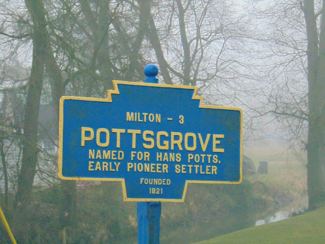
Posts

Showing posts from 2022

Star Gazers' Stone

Image
  One of the most important surveying markers in the United States, and perhaps, the world, is located in an otherwise unassuming field at Embreeville in Newlin Township in Chester County, Pennsylvania. That marker is the Star Gazers' Stone, which is the land marker that was used in 1764 by 18th century astronomers Charles Mason and Jeremiah Dixon to determine the true boundary between Pennsylvania and Maryland. At the time, the colonies of Maryland and Pennsylvania had a disputed border thanks to competing royal charters of the time. Maryland and Pennsylvania both claimed the land between the 39th and 40th parallels according to the charters granted to each colony, and this would have included the City of Philadelphia. The issue was unresolved until the British Crown intervened in 1760, ordering Frederick Calvert, 6th Baron Baltimore to accept a border agreement signed in 1732. As part of the settlement, the Penns and Calverts commissioned the team of English astronomers Charles M

Hassenplug Covered Bridge

Image
The Hassenplug Covered Bridge is a 70 foot long covered bridge located over the Buffalo Creek in Mifflinburg, Pennsylvania. The bridge was named for the Hassenplug family, who had a home nearby to the bridge. Built in 1825, it is believed to be one of the oldest remaining historic covered bridges in the United States, with only the Hyde Hall Covered Bridge in Upstate New York possibly being older as it was built the same year. The covered bridge was built with a Burr arch truss design. The covered bridge was restored or modernized in 1959. During the restoration process, the wooden deck was replaced with steel grating and a pier was added to allow for heavier vehicles to cross. The bridge is still open to traffic today on North Fourth Street in Mifflinburg, allowing for a weight limit of 6 tons. There is a small parking area at the south end of the bridge, which is also shared by the one mile long Koons Trail . How to Get There: Sources and Links: Bridgehunter.com -  Hassenplug Covere

Keefers Mill Covered Bridge

Image
  Spanning 75 feet across the Chillisquaque Creek on Keefer Mill Road near Washingtonville in Montour County, Pennsylvania is the Keefers Mill Covered Bridge. Also known as the Keefer Covered Bridge No. 7 in Montour County's covered bridge inventory, it is the only remaining bridge that is located entirely within Montour County, although some covered bridges cross the border of the county. The bridge was built in 1853 by George Butler at a cost of $498.00. Butler designed and built the covered bridge using a Burr arch truss design. The site of the Keefers Mill Covered Bridge was near Geringer's Mill, but not much is known of that mill. However, records do list the builder of the mill as George W. Keefer, who built a number of mills and covered bridges throughout north central Pennsylvania and it is quite possible that the covered bridge was named for Keefer. The covered bridge was added to the National Register of Historic Places in 1979 and was rehabilitated in 1983 after sitt

Windsor

Image
   WINDSOR - Founded 1905. Formerly Windsorville. Named for Windsor, England. Early settlers to Windsor were involved in the cigar making and iron ore mining industries that had become common around York County, Pennsylvania. How to Get There: Sources and Links: Red Lion Historical Society -  Windsor Township History Windsor Township -  History

Elysburg

Image
  ELYSBURG - Founded 1830. Named for Ely family, formerly Petersburg. Elysburg is best known as the home of the Knoebels Amusement Park and the Roaring Branch Tract of the Weiser State Forest. How to Get There: Sources and Links: Susquehanna River Valley - Elysburg, Pennsylvania

Wertz's Red Covered Bridge

Image
  Pennsylvania's longest single span is the Wertz's Red Covered Bridge, spanning over the Tulpehocken Creek and the former Union Canal (which was built in the 19th Century to connect the Schuylkill and Susquehanna Rivers). Located in Reading, it is also known as Wertz's Covered Bridge or just Red Covered Bridge, acknowledging the red color the covered bridge is painted in. The 218 foot long Burr arch truss designed covered bridge bridge was built in 1867 by Amandas Knerr at the cost of $7,450. While 37 covered bridges once crossed over various bodies of water throughout Berks County, Pennsylvania, the Wertz's Red Covered Bridge is one of five historic covered bridges that are still found dotting the county. The covered bridge was named after Wertz’s Mill, which was a prominent mill located just downstream on the west bank of the Tulpehocken Creek. Around the year 1916, the  Wertz’s Mill was destroyed by fire and today little remains of the mill. At the time of its cons

Refton

Image
  REFTON - Founded 1877. Founded by Daniel Herr, pioneer. Refton is located along US Route 222 in Lancaster County, between Lancaster and Quarryville. How to Get There:

Kidd's Mill Covered Bridge

Image
   Built in 1868 to replace a span destroyed by flooding along the Shenango River, the Kidd's Mills Covered Bridge is the last remaining historic covered bridge located in Mercer County, Pennsylvania. Known in Mercer County's inventory as Bridge # 1801, the bridge is located on Township Road 471, about a half mile east of PA 18, near the community of Transfer in Pymatuning Township. The 124 foot long covered bridge was designed using a Smith through truss design and is the easternmost covered bridge that utilizes the Smith through truss design. The bridge was built by the Smith Bridge Company of  Tipp City, Ohio  (formerly known as Tippecanoe City). The Smith truss design for a covered bridge was kind of like the bridge version of a Craftsman home, as it was not constructed on site. Devised and patented in 1867 by Robert Smith, both the tension and compression members were all wood. During the period of 1867 to 1870, Smith built fifteen of these patented structures in Miami Cou

Sam Wagner Covered Bridge

Image
  Also known as the Gottlieb Brown Covered Bridge, the Sam Wagner Covered Bridge spans over the Chillisquaque Creek on the county line between Montour and Northumberland Counties on Bridge Road near Potts Grove, Pennsylvania. The 95 foot long covered bridge was built in 1881 by George W. Keefer at a cost of $1,939. George Keefer was the builder of a number of covered bridges in this region of Pennsylvania (the Keefer Station Covered Bridge near Sunbury, Pennsylvania is another covered bridge he built), so the powers that be knew that they would get a quality finished product. Constructed with a single-span multiple Kingpost with a Burr arch truss design, the bridge serves one lane of vehicular traffic with a weight limit of 3 tons.  The Sam Wagner Covered Bridge was placed on the National Register of Historic Places in 1979 and was rehabilitated in 1985. As Northumberland and Montour Counties jointly own the covered bridge, they pledged $17,500 each for bridge repairs when restoration

Potts Grove

Image
  POTTS GROVE - Founded 1821. Named for Hans Potts, early pioneer settler. How to Get There: Sources and Links: Valley Girl Views - Pottsgrove, Northumberland County

Sodom Octagonal Schoolhouse

Image
  One of several octagonal shaped one room schoolhouses that were built in Pennsylvania, the Sodom Octagonal Schoolhouse on PA 45 east of Montandon, Pennsylvania may be one of the best preserved examples of such. While the schoolhouse is of a rather simple design that is said to be based on a design from a church in Scotland and features limestone quarried from nearby sources, there are some legends revolving the construction of the school and how the school got its name. The schoolhouse has a single chimney in the center of the roof, seven windows, and a single door on the south side facing the road. At one time, the front of the schoolhouse also had a belltower and a cupola. A vestibule was once attached where students hung their coats and a wood-burning stove stood in the center. On the north wall of the school was a blackboard with a 30 foot long, 10 foot wide, 10 inch high platform for the teacher. Six long rough desks were placed parallel to the walls and two more were placed in

Bondsville Mill Park

Image
  The site where the Bondsville Mill Park on Bondsville Road in Chester County's East Brandywine Township is located has long been the site of mills. There have been grist mills on the site of what is now Bondsville Mill Park since the 18th Century, but the remains of a woolen mill where Bondsville Mill Park is located was established in 1841. Abraham Bond, believed to be the third owner of the mill, opened the Bond Woolen Factory established the factory village of Bondsville, not far from Downingtown, Pennsylvania. The Bond Woolen Factory produced blue jeans through its tenure during the 1840s. Unfortunately, a fire severely damaged the mill in 1844, but it was not the end of the mill. Rather, it was a catalyst for a number of changes and improvements for the future of the mill. In 1848, William McFarland purchased the mill, and during the Civil War, the mill produced uniforms for the Union Army. In 1864, James Roberts acquired the mill and by 1870, the mill was powered by water a